• Home
  • About
  • Faculty Experts
  • For The Media
  • ’Cuse Conversations Podcast
  • Topics
    • Alumni
    • Events
    • Faculty
    • Students
    • All Topics
  • Contact
  • Submit
STEM
  • All News
  • Arts & Culture
  • Business & Economy
  • Campus & Community
  • Health & Society
  • Media, Law & Policy
  • STEM
  • Veterans
  • University Statements
  • Syracuse University Impact
  • |
  • The Peel
  • Athletics
Sections
  • All News
  • Arts & Culture
  • Business & Economy
  • Campus & Community
  • Health & Society
  • Media, Law & Policy
  • STEM
  • Veterans
  • University Statements
  • Syracuse University Impact
  • |
  • The Peel
  • Athletics
  • Home
  • About
  • Faculty Experts
  • For The Media
  • ’Cuse Conversations Podcast
  • Topics
    • Alumni
    • Events
    • Faculty
    • Students
    • All Topics
  • Contact
  • Submit
STEM

Researchers Explore the Factors That Shaped the Cauca River Canyon in the Andes

Wednesday, March 16, 2022, By Dan Bernardi
Share
College of Arts and SciencesDepartment of Earth and Environmental SciencesfacultyResearch and CreativeStudents

With steep walls and deep valleys, the Grand Canyon in the western United States or the massive gorges that saw through the margins of the Tibetan Plateau are some of the most awesome and spectacular landforms on the planet. But have you ever wondered how they are formed?

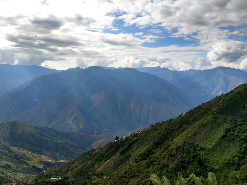
mountains in Andes

The spectacular Cauca River Canyon in the Northern Andes of Colombia. The Cauca River has incised up to 2-3 km into the bedrock of the mountains during the past 6-7 Ma. Canyon walls are steep, and landslides are common.

Some studies have proposed that canyons form when a mountain range grows in height and a river running through it cuts into the rock formation like a knife, ultimately forming gorges. Other studies have associated canyon incision with past changes in climate. For example, in the Miocene (about 15 million years ago), an increase in precipitation rates is believed to be the cause behind rapid incision of the Mekong River in China.

But what about canyons in hot and humid tropical latitudes? Researchers from the College of Arts and Sciences’ (A&S) Department of Earth and Environmental Sciences (EES) recently embarked on a research expedition to the Tropical Andes of Colombia to study the massive Cauca River canyon.

The team’s objective was to determine the age of formation of the Cauca River canyon and then compare that with known tectonic and climatic processes that happened in the region during the past 10 million years to figure out what caused its incision. The team concluded that erosion in the Cauca River canyon was driven by tectonic processes.

Their study, which expands the understanding of erosion hotspots in tropical landscapes and why they occur in certain areas, will be an important source of information for decision makers who must take erosion and landslides into account during infrastructure planning. Their results were presented in two papers that appeared in Global and Planetary Change and Geological Society of America Bulletin.

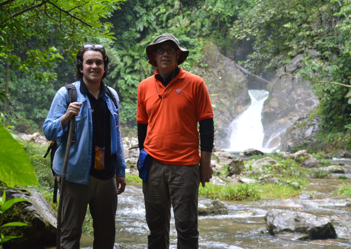
two people standing in front of waterfall

Nicolas Pérez-Consuegra (left) and Gregory Hoke standing in front of a waterfall in the Caqueta Canyon in the tropical Andes during the summer of 2018.

The study was led by MIT postdoctoral fellow Nicolás Pérez-Consuegra G’21, Ph.D., who completed the research as a graduate student in EES with support from the Graduate School’s Research Excellence Doctoral Funding Program and an A&S doctoral fellowship. He collaborated on the project with his advisor Gregory Hoke, associate professor and chair of EES, Paul Fitzgerald, professor in EES, and international colleagues from the University of Potsdam, Germany; the German Centre for Geoscience Research, Germany; the University of Granada, Spain; and Ecopetrol Brazil, Rio de Janeiro, Brazil.

The authors used a combination of techniques. They analyzed the landscape using data derived from satellite imagery; carried out fieldwork to collect rock samples along one of the steep walls of the canyon; and analyzed those rock samples using thermochronology. Thermochronology is a technique that allows the researchers to figure out when and how fast a canyon is carved into a mountain by recording when the rocks cooled to surface temperatures. Certain minerals, in this case apatite, become radioactive clocks as the rocks cool.

In their landscape analysis they observed a surprising feature—a massive plateau elevated ~2.5 km (~8,200 ft) surrounded by hundreds of waterfalls and very steep rivers draining the flanks of the plateau.

“Finding such a flat landform at high elevations in a tropical climate is unexpected and suggested that the topography could not be very old,” says Pérez-Consuegra. “If the topography had been old, the rivers would have probably already eroded the plateau.”

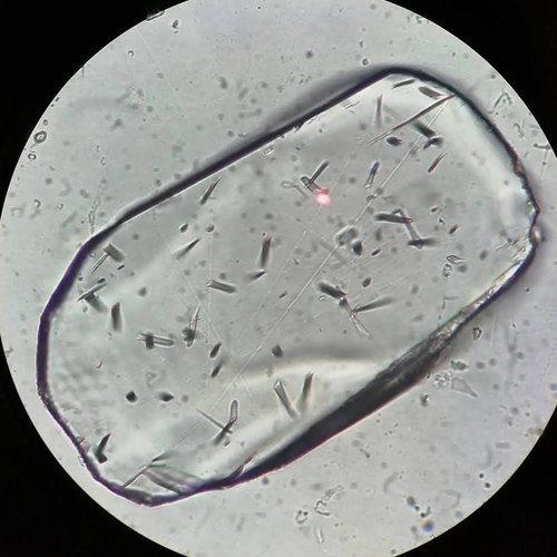
Apatite crystal under a microscope

Apatite crystal under a microscope at Paul Fitzgerald’s laboratory at Syracuse University. It was extracted from a granitic rock at the Cauca River Canyon in Colombia. The linear features observed are fission tracks which track the cooling history of a rock through time. This apatite crystal has a length of ~150 micrometers.

What might have caused these elevated plateaus? Between the period of 50 to 10 million years ago, the research team believes erosion smoothed the landscape to low, rolling hills. About 10 million years ago tectonic forces began lifting that smoothed landscape, creating a plateau perched at its current elevation of ~2.5 km (~8,200 ft). This was likely caused by a change in the angle of the oceanic plate that subducts beneath northern South America through a process called slab flattening.

Their findings provide a plausible link between tectonic processes rooted deep in the Earth and erosion in the form of canyons being carved by rivers. Pérez-Consuegra says the team is now trying to determine catchment-scale erosion rates in the Central Cordillera of Colombia to discover how fast the rivers are incising and eroding into the plateau. They have collected sand from more than 20 rivers to calculate erosion rates through a technique which uses cosmogenic nuclides to estimate the length of time rock takes to traverse the upper 4 ft. (1.2 m) of the Earth’s surface as it is converted to sediment. Their results will pinpoint the areas where erosion is most active, and thus those same places where infrastructure and human populations will be most vulnerable.

  • Author

Dan Bernardi

  • Recent
  • Utility Projects to Begin on Campus This Week; Temporary Closures and Detours Expected Throughout the Summer
    Monday, May 12, 2025, By Jennifer DeMarchi
  • 3 New Members Elected to University’s Board of Trustees
    Monday, May 12, 2025, By Eileen Korey
  • Arts and Sciences Hosts Inaugural Scholarship and Research Gala
    Friday, May 9, 2025, By Sean Grogan
  • Chancellor Kent Syverud Honored as Distinguished Citizen of the Year at 57th Annual ScoutPower Event
    Thursday, May 8, 2025, By News Staff
  • New Maymester Program Allows Student-Athletes to Develop ‘Democracy Playbook’
    Thursday, May 8, 2025, By Wendy S. Loughlin

More In STEM

Chloe Britton Naime Committed to Advocating for Improved Outcomes for Neurodivergent Individuals

Chloe Britton Naime ’25 is about to complete a challenging and rare dual major program in both mechanical engineering from the College of Engineering and Computer Science and neuroscience from the College of Arts and Sciences. Even more impressive? Britton…

Graduating Research Quartet Synthesizes Long-Lasting Friendships Through Chemistry

When Jesse Buck ’25, Isabella Chavez Miranda ’25, Lucy Olcott ’25 and Morgan Opp ’25 started as student researchers in medicinal chemist Robert Doyle’s lab, they hoped to hone their research skills. It quickly became evident this would be unlike…

Biologist Reveals New Insights Into Fish’s Unique Attachment Mechanism

On a wave-battered rock in the Northern Pacific Ocean, a fish called the sculpin grips the surface firmly to maintain stability in its harsh environment. Unlike sea urchins, which use their glue-secreting tube feet to adhere to their surroundings, sculpins…

Distinguished ECS Professor Pramod K. Varshney Establishes Endowed Faculty Fellowship

Distinguished Professor Pramod K. Varshney has exemplified Orange excellence since joining the University as a 23-year-old faculty member. A world-renowned researcher and educator, he’s been recognized for his seminal contributions to information fusion and related fields, introducing new, innovative courses…

Earth Day Spotlight: The Science Behind Heat Pumps (Video)

Peter Wirth has a two-fold strategy when it comes to renovating his home. The Brooklyn, New York, native has called Central New York home for more than 40 years. Nestled on a quiet cul-de-sac in Fayetteville, New York, the 1960s-era…

Subscribe to SU Today

If you need help with your subscription, contact sunews@syr.edu.

Connect With Us

  • X
  • Facebook
  • Instagram
  • Youtube
  • LinkedIn
Social Media Directory

For the Media

Find an Expert Follow @SyracuseUNews
  • Facebook
  • Instagram
  • Youtube
  • LinkedIn
  • @SyracuseU
  • @SyracuseUNews
  • Social Media Directory
  • Accessibility
  • Privacy
  • Campus Status
  • Syracuse.edu
© 2025 Syracuse University News. All Rights Reserved.